
Twelve ONUs Just Went Down. Is That One Splitter, or Twelve Problems?
It is 21:40. Twelve ONUs on PON port g0/3 drop inside the same two minutes. Your NMS tells you exactly which twelve, with serials, last known Rx power and a down reason for each. All useful, and all insufficient for the only question that matters right now: how big is this?
Those twelve ONUs could mean three very different things. Twelve homes that lost mains power together, in which case your fiber is fine and there is nothing to dispatch. One failed splitter feeding all twelve, which is one van and forty minutes. Or the first twelve of a feeder cut that is still spreading, and another two hundred subscribers are about to follow. Same alarm, same twelve rows, three completely different responses.
Working that out has traditionally meant a phone call to whoever knows the area, or a fiber layout drawing in someone's Drive folder that was last accurate in 2023. So on July 30 we shipped the ONU GPS Map.
The fault domain is a place, not a port
Every NMS models the logical network: ports, links, sessions, which ONU is registered where. For the core that is enough. If a link between two POPs drops, the two endpoints tell you everything.
The last mile does not work that way. A splitter is a physical box on a physical pole feeding physical homes down physical streets. When a car hits that pole, what fails is a geographic region, and no amount of logical topology will draw it for you.
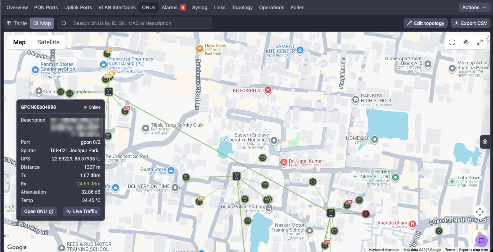
So this is deliberately not another topology view. It is your OLT, your splitter cabinets and your subscriber ONUs on their real coordinates, coloured by their real current state, answering the question in the shape operators actually ask it: are the red dots scattered across a suburb, or stacked on top of each other in one lane?
Click any ONU and you get its port, its splitter, its coordinates, its distance from the OLT, and the optical numbers that matter: Tx, Rx, attenuation, temperature. From there you are one click from opening it or watching its live traffic.
Splitters are what turn a map into a fault domain
Dots on a map are pretty. Dots with the ODN drawn between them are diagnostic.
You place splitters yourself, in edit mode, by right-clicking where the cabinet actually is. Each gets a label, coordinates, a parent and a split ratio from 1:2 to 1:64. The parent builds the hierarchy: a splitter fed from an OLT PON port is primary, one fed from a primary is secondary, then tertiary, then quaternary. Four levels covers every real ODN design we have seen, including the deeply cascaded ones, and most operators label them to match (PRI-08, SEC-081, TER-021) so the tier is legible straight off the map.
There is one rule NetSense enforces: an ONU can only be assigned to a splitter whose effective PON port matches the port it is actually registered on. You cannot draw a network that could not physically exist. The geography is yours to author, but the OLT-to-ONU relationships underneath come from discovery and are not editable. When re-discovery moves an ONU to a different port, NetSense quietly drops the now-impossible splitter association and keeps the coordinates. The map degrades honestly rather than lying to you.
The right sidebar is what turns the picture into a triage tool. Filter by status, by down reason, by Rx power band, by tier. Filter to "power off" and a red cluster is a grid problem you can stop worrying about. Filter to "optical loss" and the same cluster is a van. Filter by Rx band and you get something we did not plan for: a geographic heat map of the branches quietly running out of margin. Operators started using it as a proactive survey tool within days. Export the filtered view to CSV and the "mapped" flag turns "we should map the network" into an assignable work list.
Getting coordinates in, honestly
The first question every operator asks is whether NetSense can just read GPS from the ONU. It cannot, and neither can anything else. No commodity ONU, router or gateway ships with a GPS modem, because it would add cost to a device whose entire commercial logic is being cheap.
So coordinates come from three places, and most operators use all three: manual entry through the ONU table or a right-click on the map; field capture during installs and home visits, which is the path that actually scales because the data collects itself during ordinary work; and bulk upload, where you send us a sheet of OLT, ONU serial and lat/long and we load it.
Two things to know before you start. Bulk upload is not yet a self-service screen. Today it is a request to support and we run it, which is fast but is a ticket rather than a button, and a proper upload interface is being built. And the map needs a Google Maps API key, with a platform default available and the option to supply your own if you are doing heavy data entry.
The same map, in the field engineer's pocket
A fiber map that only exists on a NOC monitor helps the person least likely to be standing next to the fault.
So the ONU GPS Map is in the NetSense field engineer mobile app too, straight from the OLT view. Same markers, same splitter hierarchy, same down reasons the NOC is looking at. When the NOC says "it looks like the splitter on the corner," the technician can see the same corner.
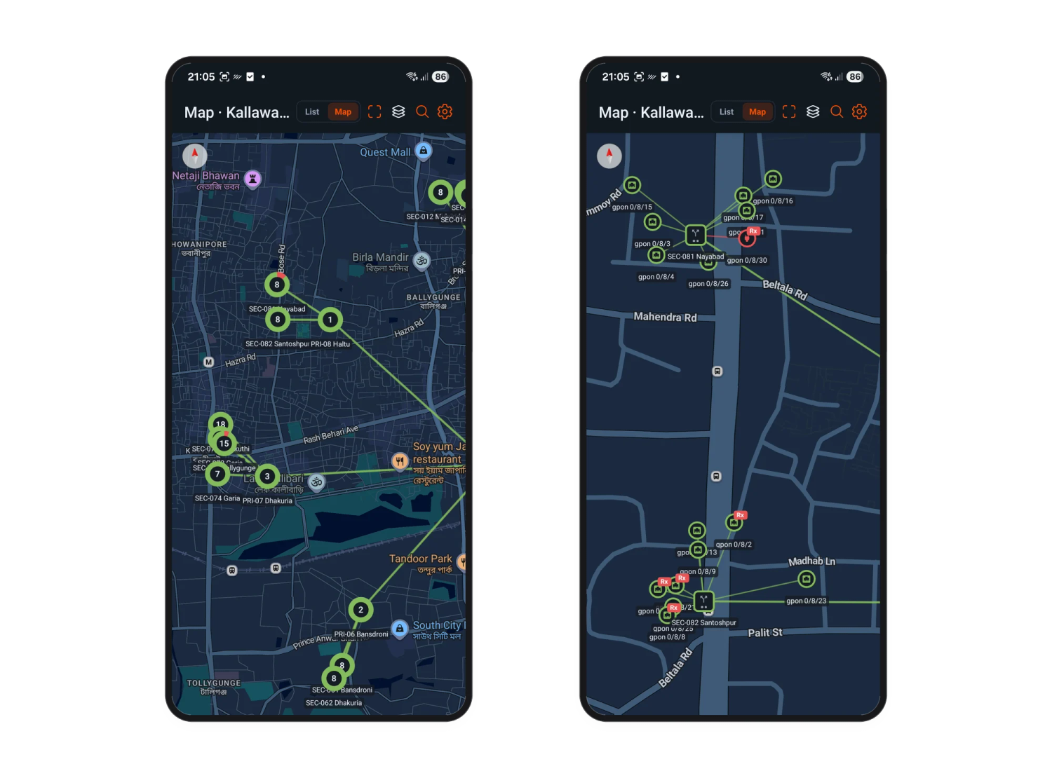
Zoomed out (left) you get the shape of the access network, each marker carrying the count of ONUs collapsed underneath it. Eighteen here, fifteen there, seven on the next one. That number alone is a blast-radius estimate before you have clicked anything.
Zoom in (right) and the clusters break into individual ONUs, each labelled with its PON port. The red Rx badges are ONUs whose receive power has left the normal range. That is the pattern worth training your NOC to read: scattered Rx flags are unrelated drop-cable problems and they get scheduled, but four Rx flags stacked around one splitter are not four coincidences. They are one piece of fiber, visible before a single subscriber has gone offline.
This first mobile release is view-only by design. Editing coordinates from the phone, the version that lets a technician capture the location while standing at the pole, is next.
What is not done yet
The map shipped alongside a rework of the Partial PON Port Down alarm, which now lets you filter by down reason and set a ten or thirty minute window so it fires on ONUs that just went down rather than the long-term offline crowd. That is the intended pairing: the alarm says something broke on g0/3, the map says whether it is one cabinet or the whole port. Background on why partial failures are the hardest PON fault to catch is in Detecting Partial PON Port Failures.
In the interest of not overselling a two-week-old feature, here is what is still missing:
- Self-service bulk import, and mobile editing with field coordinate capture. Both in progress.
- Pin-drop entry instead of typing coordinates, plus showing the technician's own location. Requested by field teams, agreed, no date.
- KMZ import beyond bare coordinates. We tested a real Google Earth export with splitters, joint boxes and loop metadata. The GPS points render; none of the rich metadata is extracted yet.
Geocoding from an existing address database keeps coming up too. It is plausible for a rough first pass, but address-derived coordinates in dense urban geography are not accurate enough to trust for splitter-level fault isolation, and we would rather ship something slower and correct.
Most of this shape came from operators pushing on it in production while it was still warm. The tier model went to four levels because a real ODN needed four. The Rx band filter got used as a survey tool by someone who was supposed to be doing incident triage. None of that would have been in a spec, and the fastest route from a workaround to a feature has always been a customer telling us the thing is nearly right but not quite.
Try it
NetSense is free forever up to 1,000 nodes. No card, no trial clock. That is enough to put a full OLT with its splitters and ONUs on the map and see whether it changes how your NOC triages a partial port failure. Details on pricing, or book a live demo and bring one of your own OLTs.
Already a customer? Open any OLT and look for the map link. If your ONUs have no coordinates yet, send us the ones you do have. One PON port's worth is enough to see the shape of it.
Frequently Asked Questions
- How do I tell if multiple ONUs going down at once is one splitter failure or separate faults?
- Plot the ONUs on a geographic map along with the splitters that feed them and look at where the down markers sit. Faults on separate drop cables scatter across a service area, while a splitter or feeder failure shows up as every ONU under one splitter going down together in one physical location. Filtering by down reason separates it further: "power off" across a cluster usually means a local grid outage rather than a fiber problem, while "optical loss" points at the ODN.
- Can an ONU or CPE report its own GPS location automatically?
- No. No commodity ONU, ONT, router or residential gateway ships with a GPS receiver, because the added cost is not viable on a device built to a low price point. Coordinates have to come from field capture during installs and home visits, from an existing installation or address database, or from manual entry. The practical approach for most ISPs is to capture coordinates during normal technician visits so the map fills in over time.
- How many levels of optical splitters can a fiber network map represent?
- The NetSense ONU GPS Map supports four cascade levels: primary (fed directly from an OLT PON port), secondary, tertiary and quaternary. Each splitter carries its own split ratio from 1:2 through 1:64 and its own coordinates. Four levels covers essentially all real GPON and EPON ODN designs, including heavily cascaded urban builds.
- What GPS coordinate format should I use for ONU locations?
- Decimal degrees with a dot as the decimal separator, for example `28.71694, 77.17449`. Latitude comes first, longitude second, which is the order Google Maps uses when you copy a location but the opposite of some GIS exports. Latitude must be within plus or minus 90 and longitude within plus or minus 180.
- Can field engineers see the fiber map on their phone?
- Yes. The ONU GPS Map is available in the NetSense field engineer mobile app as well as the web interface, reachable directly from the OLT view, so the technician in the van sees the same splitter hierarchy and the same colour-coded ONU status as the NOC. The first mobile release is view-only; editing coordinates from the phone is in active development.